Nestled high above Asia’s crowded plains and winding river systems, the Hindu Kush-Himalayan (HKH) mountain ranges have stood tall as guardians of life for eternity, their snow-covered peaks storing nature’s most precious resource: water.
However, snow cover in the region plummeted to a record low in the winter of 2024/25, threatening water security in Asia’s major river basins and biodiversity across large swathes of the continent. Making the situation even more alarming is the fact that this was the third consecutive winter that the region has received below-average snow persistence – the duration of time that snow remains on the ground in a given year.
The HKH mountain range stretches across eight countries on the Asian continent – Afghanistan, Bangladesh, Bhutan, China, India, Myanmar, Nepal, and Pakistan. These mountains hold the largest reserves of ice and snow, and the most glaciers outside the polar regions, earning the nickname “Third Pole”.
On average, snowmelt contributes around 25 per cent of the total annual runoff of twelve major river systems in Asia. Therefore, anomalies in seasonal snow persistence have a dramatic impact on the water supply for the two billion people who reside in these river basins and depend on rivers and reservoirs fed by meltwater from the region’s snow-capped peaks. It’s an acceleration of a trend observed over the past quarter century, and the implications of this trend are enormous.
The river basins it supplies include the Amu Darya Basin which feeds rivers in Afghanistan, Tajikistan, Turkmenistan, and Uzbekistan; the Brahmaputra Basin which feeds rivers in China (Tibet), India, Bhutan, and Bangladesh; the Ganges Basin which feeds rivers in Nepal, India, and Bangladesh; the Helmand Basin which feeds rivers in Afghanistan and Iran; the Indus Basin which feeds rivers in China (Tibet), India, Pakistan, and Afghanistan; the Irrawaddy Basin which feeds rivers in China and Myanmar; the Mekong Basin which feeds rivers in China, Myanmar, Laos, Thailand, Cambodia, and Vietnam; the Salween Basin which feeds rivers in China, Myanmar, and Thailand; the Tarim Basin which feeds rivers in China (Xinjiang region); the Tibetan Plateau which feeds rivers in China (affects multiple basins like Indus, Mekong and Yangtze); the Yangtze Basin which feeds rivers in China; and the Yellow River Basin which also feeds rivers in China.
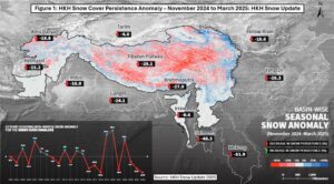
Figure 1 shows the spatial distribution of snow persistence anomaly, and the overlaid graph is the HKH-wide average seasonal snow anomaly (November-March) for the last twenty-three years.
The alarm has been raised by a recent report from the International Centre for Integrated Mountain Development (ICIMOD), the regional mountain climate watchdog. The annual report provided an analysis of seasonal snow persistence for the November to March period.
The seasonal snowmelt is critical for regional water availability, especially the early melt, which flushes river systems for agriculture and hydroelectric power, and nourishes countless wetlands ahead of summer. Continuous deficits in water from snowmelt mean water volumes progressively decrease each year, with drinking water, food production, power generation, and the environment being the biggest casualties.
According to the report, below-normal snow persistence occurred thirteen times between 2003 and 2025, but the growing concern is the increasing frequency and intensity of such occurrences in recent times. The 2024 update reported a decrease in snow persistence of 18.5 per cent compared to the mean snow persistence recorded in the preceding two decades. However, the most recent winter saw historically low snow persistence at 23.6 per cent under the 20-year average, the lowest recorded since the inception of the monitoring twenty-three years ago.
Recorded snow persistence was below normal across all twelve of the major river basins, with the most alarming decline observed in the Mekong (-51.9 per cent) and Salween (-48.3 per cent) basins, followed by the Tibetan Plateau (-29.1 per cent), Brahmaputra (-27.9 per cent), Yangtze (-26.3 per cent), the Ganges (-24.1 per cent), the Yellow River (-18.6 per cent) and the Helmand (-15.2 per cent).
Even snow-dominant basins such as the Amu Darya (-18.8 per cent) and Indus (-16.0 per cent) experienced alarming reductions in 2024/25. While still negative, the least affected basins last winter were the Tarim (-4.0 per cent) and the Irrawaddy (-0.6 per cent).
This will inevitably lead to lower and warmer river flows, increased groundwater extraction downstream, less soak to replenish artesian basins, and a heightened drought risk due to lower atmospheric water. It could ultimately lead to catastrophic crop losses in coming years, jeopardising domestic and international food supply, and potentially make cross-border water-sharing arrangements, already extremely politically sensitive, a major flashpoint.
Call your local Grain Brokers Australia representative on 1300 946 544 to discuss your grain marketing needs.